Where Mountains Meet the Sea
Moving forward on my three-day journey in Antique province, I hopped on a bus in Pandan municipality, southbound for the town of Culasi. I alighted downtown, walked a bit toward the tourist center, located a few blocks behind the modest municipal building, to book a day trip to Mararison Island.
Culasi was to me, a realization of Antique’s moniker, “The Land Where the Mountains Meet the Sea.” From where I stood, there was Mount Madjaas on one side and on the other, the sea, with a clear view of the island I went for that would only take 15 minutes to reach.
 |
| Mararison Island in Culasi, Antique |
 |
Majestic Madjaas, a Legend
Panay Island’s highest peak at 2,117 meters, Madjaas is deemed one of the toughest mountains to challenge in the Visayas region. “Maganda po ang Madjaas, Sir, pero mag-allot po kayo (ng) mga 3 to 4 days para matapos” (Madjaas is such a beauty, Sir, but you need to allot three to four days to complete the climb), a staffer butted in as I flip through the town’s tourism leaflet.
 |
| Culasi Tourism Center |
Seasoned mountaineers suggest the same time frame for traversing the mountain’s 15-kilometer stony trail. Madjaas seem harder to climb in the rainy season, but it might not be as rewarding in the summer because the lofty mountain has 14 known waterfalls scattered throughout its jungles. Some of them are along the hiking trail, some are deep-seated in the foliage, while some can be seen by the naked eye, says the boatman, as we behold an unobstructed view of the mountain during our transit to Mararison Island.
Besides its obvious environmental importance, Madjaas is also a revered mountain and a significant piece of Antique’s culture and tradition. Local folklore has it that Madjaas was a mother to three daughters—”spoiled brats,” as Ate Cecil, our island host, described them.
 |
| Mount Madjaas behind the clouds, viewed from Mararison Island's sandbar |
“Lagi silang nag-aaway-away kaya isang araw, pinarusahan sila ni Madjaas at itinapon sila sa dagat” (they always quarrel, so there came one day when Madjaas had had enough and she tossed them into the sea), she narrated while we were huffing and puffing toward the island's highest peak.
The estranged children, the legend goes, became the islands of Batbatan, Maniguin and Mararison. All under the Culasi’s jurisdiction, Maniguin is the farthest from mainland (3 hours), then Batbatan (45 minutes), and Mararison is within nearest reach.
 |
| Mararison Island viewed from mainland Culasi |
To the top of Mararison Island
For its scenic, “Batanes-like” waters and rolling hills, Mararison Island (also Malalison) positioned Culasi to its rightful place on Antique's tourism map. The island was widely discovered only in 2014 through the efforts of local tourism officers and social media influencers.
As a result of the tourism boom, the once fishing community became an island of local tour guides. Their houses became homestay accommodations and the outrigger boats formerly used for fishing are now used to transport tourists.
 |
| View from Lantawan Hill |
 |
| The author at the sandbar |
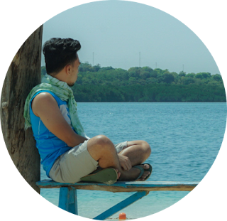
The island boasts off its relatively lengthy sand bar that juts out from its creamy shoreline, its surrounding waters of varying blue hues, and its verdant hills which offers a sweeping vista of the sea and the mountain range of mainland Antique.
From the beach, we trekked Lantawan Hill, Mararison Island's highest viewpoint. There, one would witness the view that was probably the reason why the island became that popular.
 |
| Mararison's rolling hills, Nablag Islet on far end |
 |
| The trail passes by a ravine that leads directly to the sea |
Thirty minutes of relishing the sight and catching our breaths at the peak, we traversed the hill and reached the island's rear where Nablag Islet, an uninhabited land mass, was situated. Nestled only a few meters from the main island, Nablag Islet can be reached by foot if the tide recedes. Its name, Ate Cecil explained, was derived from the Kinaray-a (Antique's main dialect) word “nabulag,” which means “nahiwalay” (detached) in Tagalog.
 |
| A mini cave on the traversed side of the island |
 |
| Nablag Islet |
The sun had peaked as we trekked back to the beach where a hearty seafood meal awaited us. A combined view of Mararison sandbar, the pastoral Madjaas and the blue sea in between them complemented the late-lunch chow.
 |
| Mountain, sandbar and sea view as we take our lunch |
I had half an hour left to bask in the shallow jade waters the surrounds the sand bar. I needed to be back at the mainland so I could catch the last passenger van going to Tibiao town where I would spend the night.
READ ALSO: By the Waters of Tibiao, Antique
Follow and subscribe to PinoyTravelogue.com on Facebook, Twitter, Instagram and TikTok for more travel stories and updates.


